Gold Creek Mine, Montana
Gold-Silver-Copper + REE Project, Flexible Financing Terms
Summary
Location and Access
The Gold Creek Mine is located near the headwaters of Gold Creek in Granite County, Montana. It is accessible from Interstate 90 off exit at Gold Creek, Montana. Access road is mostly gravel and is accessible by car. Heavy equipment accessible. The mine property its situated at 7000 feet elevation and generally is snowed in from December-March.
Description
Geology
The project site is situated in the northeastern portion of the Flint Creek Range near a contact between the Royal Stock and Paleozoic and Mesozoic sedimentary rocks. The dominant rock in the district is granodiorite. In the lodes, ores consist mainly of quartz calcite, pyrite and chalcopyrite with lesser amounts of galena, sphalerite, and tetrahedrite. Alteration of wall rock has been extensive. Some of the granite is a felty mass of sericite, calcite, quartz and pyrite; the alteration is such that often the original texture is no longer evident. An east-west trending precious metal vein system extends for over a mile and contains high grade ore with 0.01-1.06 OPT Au, 20-70 OPT Ag and 0.8-3.8 percent Cu with lesser amounts of molybdenum and tungsten. Anomalously high concentrations of praseodymium and niobium were noted in samples collected from the floor of the Pineau Placer Mine. Numerous other REEs have been identified but very limited information is available regarding grade or ore volume.
Much of the placer gold is deposited along granitic bedrock and is contained in glacial till deposited during different stages of glacial advance. The majority of the coarse gold is found within till of the earliest stage which rests directly on bedrock and is usually 1-3 feet thick. The early till is comprised mostly of tan and gray quartzite clasts and usually exhibits a rusty color owing to high iron content. Some gold is found in an intermediate aged till which is comprised of a greater proportion of metasedimentary and metamorphic rocks such as schist and hornfels. Younger till covers much of the area as varying thicknesses (2-12 feet average) of barren overburden and is comprised almost entirely of white granodiorite boulders and clasts. Erosional channels, possibly ancestral stream channels, and/or joints in the underlying
bedrock that trend obliquely to the present stream course act as natural traps for the
placer gold.
A geological study of the area was conducted for Montana Mining and Timber in 1985 prior to their acquisition of the unpatented claims. The report presents the results of test pit sampling and summarizes ore grade and quantity (available for inspection). Hard rock assays available on request with NDA.
History
Placer exploration began in the late 1800s and lode mine development followed shortly thereafter. The Pineau Placer (aka McFarland placer) was the largest producer on the stream itself. Although some mining was reported in 1870, serious development did not begin until 1896. From 1896 to 1913 the placer produced $35,000 (at $20/ounce). The claim was primarily worked by sluices with boulders blasted or lifted out of the stream by a derrick. Gold recovered was about 790 fine with nuggets up to 10 ounces. Placer gold appears to have originated principally from the veins in the mountainous area upstream with a significant deposit of residual placer formed from gold-bearing veins in the floor of the placer. The gold was coarse, with a minimum average size about that of a grain of wheat. It has yielded large nuggets, typically less than 10 ounces, but the largest weighed in at 27 ounces (on display at the Larabee Bank, Deer Lodge for many years). Much of the coarser gold was obtained while drift mining along bedrock.
J. H. Crockett worked the Pineau Placer in 1934. In 1934 the hydraulic operation was supported by a 450,000 gallon storage dam and 1.5 miles of ditch which delivered water with 150 feet of head to a #3 Giant nozzle. A 10-ton portable derrick was used to remove boulders and the gravel was washed in 500 feet of 20 x 20 inch sluice boxes.
The mine was worked as recently as 1983 by Clifford Jacobsen of Deer Lodge, Montana. In 1983-85, Jacobsen operated a small wash plant fed with a backhoe and the operation recovered a significant amount of coarse gold with nuggets weighing up to 14 ounces. Jacobsen abandoned the mining operation after suffering health problems and the claims were sold to Montana Mining and Timber Co. (MM&T) in 1986. MM&T continued
operations on the patented Master Mine but did not actively mine their unpatented holdings. The claims were ultimately acquired by the current owner in the mid 1990s.
Lode development resulted in the discovery of numerous high grade precious metal vein deposits. All of the vein deposits are relatively small but mineralization in the surrounding country rock is extensive and widepread.
Additional Information
Much additional information available for review. Possible earn-in with qualified drilling program. Contact Rob at 406-582-8491.
Photos
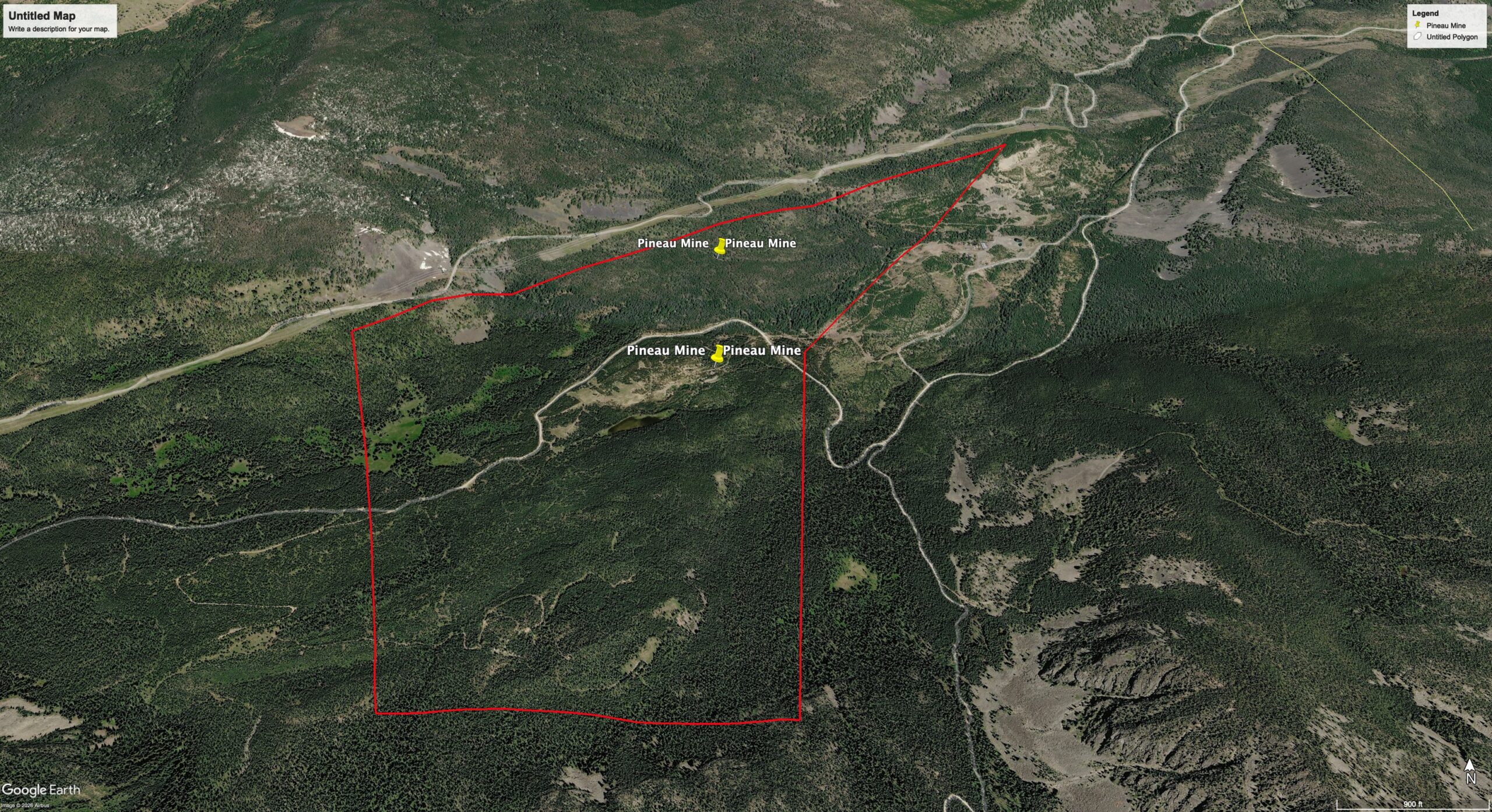
Map
Contact Seller
Please use the form below to contact the seller about this property: